- Credits
- 0
- XP
- 1
~:~|~:~ Gladden Fields ~:~|~:~
_ _ _ _ _ _ _ _ _ _ _ _ _ _ _ _ _ _ _ _ _ _ _
Project Leader: Andrewpioneer
Project Co-lead: TotiGonzales
Project Staff: Rudolphius, Foolhardyfish
Overall Progress:Project Leader: Andrewpioneer
Project Co-lead: TotiGonzales
Project Staff: Rudolphius, Foolhardyfish
Approximate Overall Progress Percentage:
Current Progress Phase: Planning
Project Road Map:
Phase 1: Planning: Current Stage
- Lore and Geography background: 100%
- Current Project Map: 100%
- Expanded Project Maps: 100%
- Town names and characteristics: 90%
- Concepts (Including Build Guides):
- Settlement: 50%
- Environment: 50%
- Terrain (Excluding Build Guides): 10%
- Main world planning: 0%
- Tree Repository 1: 15%
- Rivers:
- Marshes:
- Waterlogged Fields:
- Hills(foundation):
- Foothills(foundation):
- Ponds:
- Forests:
- Woods:
- Thickets:
- Fields & Meadows:
- Roads:
- Settlements:
- Farms:
Please Contact project staff via Discord to inquire about jobs or assignments.
Phase 1: Planning
Jobs:
- Tree Repository Jobs (1-TJ)
- Austrian Oak (Requires: N/A, Job Ready)
- Scots Pine (Requires: build guide, plot grid)
- Willow (Requires: concept, build guide, plot grid)
- European Hornbeam (Requires: concept, build guide, plot grid)
- Beech (Requires: build guide, plot grid)
Artist Assignments:
- Tree Concepts (1-TA)
- Willow
- European Hornbeam
- Environment Concepts (1-EA)
- Marshes
- Waterlogged field
- Pond
- Open River
- Meadow
- Thicket
- Forest
- Boat and Cart Repository (1-BCA)
- Boat Building
- Cart Building
- House Concepts (1-HA)
- Stilted House
- Forest House
- Campsite
Jobs:
- River Jobs (2-RJ)
- River Digging & Smoothing
- River Gradient
- River Vegetation
- Marsh Jobs (2-MJ)
- Marsh Digging & Smoothing
- Marsh Gradient
- Marsh Vegetation
- Waterlogged Fields Jobs (2-WJ)
- Pond Jobs (2-PJ)
- Forest Jobs (2-FJ)
- Thicket Jobs (2-TJ)
- Meadow & Field Jobs (2-MFJ)
Artist Assignments:
- Special Forest Details (2-SA)
- Dead Trees
- Fallen Trees
- Habitats
- Water Features (2-WA)
- Rapids
- Water Falls
- Springs
Jobs:
- Road Jobs (3-RJ)
- House Building Jobs (3-HJ)
- Settlement Street Detailing Jobs (3-SJ)
- Camp Building Jobs (3-CJ)
- Ruin Building Jobs (3-RBJ)
Artist Assignments:
- Points of Interest (3-PA)
- Interesting Road Details (3-IA)
- Larger Structures (3-LA)
- Bridge Building (3-BA)
Etymology:
Old English glaedene, "gladden" is another name for the "flag" or "iris". Loeg Ningloron, meaning Pools of the Golden Water-flowers.
Summary:
The Gladden Fields are a large wetland area on the western side of the Anduin River, extending along the banks of the Gladden River. At points during the Third Age, Hobbits, Woodsmen and the Beornings inhabited the area around, in and to the north of the marsh.
Key History:
- Early FA: Silvan Elves leave the Great Journey and pass the lake existing at the confluence of Gladden River and Anduin.
- 2 TA: Isildur and 200 Dunedain ambushed in Disaster of Gladden Fields. One Ring lost
- 1050 TA: Harfoot Migration to Eriador from Anduin Vale 1150 TA: Fallowhide and Stoor migration to Eriador from Anduin Vale
- 1356 TA: Fields around the Gladden re-settled by Stoors due to forced migrations from Angmar Wars
- 2463 TA: Deagol the Stoor finds the One Ring and is murderd by Smeagol
- 2851 TA: Saruman begins searching for the ring. Elendilmir found
- 2939 TA: Sauron’s spies search the area for the Ring
The Gladden Fields (Loeg Ningloron). In the Elder Days, when the Silvan Elves first settled there, they were a lake formed in a deep depression into which the Anduin poured from the North down the swiftest part of its course, a long descent of some seventy miles, and there mingled with the torrent of the Gladden River (Sîr Ninglor) hastening from the Mountains. The lake had been wider west of Anduin, for the eastern side of the valley was steeper; but on the east it probably reached as far as the feet of the long slopes down from the Forest (then still wooded), its reedy borders being marked by the gentler slope, just below the path that Isildur was following. The lake had become a great marsh, through which the river wandered in a wilderness of islets, and wide beds of reed and rush, and armies of yellow iris that grew taller than a man and gave their name to all the region and to the river from the Mountains about whose lower course they grew most thickly. But the marsh had receded to the east, and from the foot of the lower slopes there were now wide flats, grown with grass and small rushes on which men would walk.
Unfinished Tales, Part 3, Ch I, The Disaster of the Gladden Fields, Note 13
With Isildur went his three sons, Elendur, Aratan, and Ciryon, and his Guard of two hundred knights and soldiers, stern men of Arnor and war-hardened. Of their journey nothing is told until they had passed over the Dagorlad, and on northward into the wide and empty lands south of Greenwood the Great. On the twentieth day, as they came within far sight of the forest crowning the highlands before them..., the sky became overcast and a dark wind came up from the Sea of Rhûn laden with rain. The rain lasted for four days; so when they came to the entrance to the Vales, between Lórien and Amon Lanc, Isildur turned away from the Anduin, swollen with swift water, and went up the steep slopes on its eastern side to gain the ancient paths of the Silvan Elves that ran near the eaves of the Forest.
Unfinished Tales, Part 3, Ch 1, The Disaster of the Gladden Fields
[It] is told that he was in great pain and anguish of heart, but at first he ran like a stag from the hounds, until he came to the bottom of the valley. There he halted, to make sure that he was not pursued; for Orcs could track a fugitive in the dark by scent, and needed no eyes. Then he went on more warily, for wide flats stretched on into the gloom before him, rough and pathless, with many traps for wandering feet. So it was that he came at last to the banks of Anduin at the dead of night, and he was weary; for he had made a journey that the Dúnedain on such ground could have made no quicker... by day. The river was swirling dark and swift.... He stood for a while, alone and in despair. Then in haste he cast off all his armour and weapons, save a short sword1 at his belt, and plunged into the water. He was a man of strength and endurance that few even of the Dúnedain of that age could equal, but he had little hope to gain the other shore. Before he had gone far he was forced to turn almost north against the current; and strive as he might he was ever swept down towards the tangles of the Gladden Fields. They were nearer than he had thought, and even as he... had almost won across he found himself struggling among great rushes....
Unfinished Tales, Part 3, Ch 1, The Disaster of the Gladden Fields
“…[A]nd even as he felt the stream slacken and had almost won across he found himself struggling among great rushes and clinging weeds. There suddenly he knew that the Ring had gone. By chance, or chance well used, it had left his hand and gone where he could never hope to find it again. At first so overwhelming was his sense of loss that he struggled no more, and would have sunk and drowned. But swift as it had come the mood passed. The pain had left him. A great burden had been taken away. His feet found the river bed, and heaving himself up out of the mud he floundered through the reeds to a marshy islet close to the western shore. There he rose up out of the water: only a mortal man, a small creature lost and abandoned in the wilds of Middle-earth. But to the night-eyed Orcs that lurked there on the watch he loomed up, a monstrous shadow of fear, with a piercing eye like a star. They loosed their poisoned arrows at it, and fled. Needlessly, for Isildur unarmed was pierced through heart and throat, and without a cry he fell back into the water. No trace of his body was ever found by Elves or Men. So passed the first victim of the malice of the masterless Ring: Isildur, second King of all the Dúnedain, lord of Arnor and Gondor, and in that age of the World the last.”
Unfinished Tales, Part 3, Ch 1, The Disaster of the Gladden Fields
'[When Déagol] washed the mud away, there in his hand lay a beautiful golden ring; and it shone and glittered in the sun.... But Sméagol had been watching him from behind a tree, and as Déagol gloated over the ring, Sméagol came softly up behind.
The Fellowship of the Ring, LoTR Book 1, Ch 2, The Shadow of the Past
Lore Provide by: TheStephen
Geography:
River & landscape Morphology:
The main Gladden River channel descending from the Misty Mountains would be straighter on steeper elevation, then becoming more and more sinuous on the flat area of the ancient lakebed. Meandering channels would be found among the islets of reeds would be common. This channel would remain dominant, but have significant numbers of pools and small streams in other parts of the marsh. Channels here would not generally be deep, but could be broad and shallow. Deposited sediment would be found throughout the marsh. Small changes in terrain could be possible where trees have trapped enough sediment to build very small hills around their roots. The main Anduin channel would be a dominant waterway through the eastern end of the marsh and would not be obstructed by the marsh area. The force of water indicated in “The Disaster of the Gladden Fields” is more than enough to sweep Isildur a fair distance downstream, and therefore would have eroded any marsh blocking the main channel. The marsh would blend into the western bank of the main Anduin channel. The ground rises more steeply on the eastern side of the Anduin than the west. A small flood plain exists on the eastern bank, with a far more extensive plain on the west, incorporating the marshes. There’s mention of a ridge that the orcs come down on the eastern bank. There was also an old Silvan elf road between Amon Lanc and the Old Ford on the eastern side of the river.
River & landscape Morphology provided by: TheStephen
Maps:
Regions Map:
Settlement Map:
Inspiration:
House Inspiration:
Terrain Inspiration:
Town names and characteristics:
The Riding’s Regional Summary:
North Riding:
The North Riding is the richest surviving region in the Gladden Fields. The industry there revolves around fishing, but in the past depended on agriculture. The North is also home to the healthiest community of cottage industries. Most of these lesser industries are general in scope, including various smiths and craftsmen. The Stoors of this region are not expert artisans and produce very few goods of a higher quality than that of their neighbors. Their only notable or unique industries include boatcraft and the production of fine fishing items. Another notable industry in this riding is the milling of wood (which is rarely traded since their neighbors also share this industry). In the past the mining of surface level limestone deposits had occurred here. This region is also the central trading hub for the Stoors. Trade goods are transported from around the Gladden Fields into the main market town(N-T01).
The houses of this region are higher in quality, some feature rounded glass windows, painted doors and wood decorations. Due to the local limestone production plaster was available here, older homes may still have well weathered plaster finishes. Most plastered houses are close to town centers or belong to wealthier families, usually ones who conduct trade directly with a town. Two storey houses are uncommon; some buildings in towns have larger lofts but this is the extent of that practice. It is also more common for the Stoors of this region to keep gardens similar to their Shire relatives. Many houses outside of N-T01 are now stilted as the remaining Stoors move deeper into the marsh for safety and seclusion.
South Riding:
The South Riding is the poorer of the two surviving ridings, located to the south of the marsh and to the north of Lothlorien. At the time of Bilbo’s 111th birthday only one village is still inhabited. The industry there is centered around bog iron and the gathering of peat and wool. The large tracts of land to the south have made sheep herding a viable industry in the past, but this trade has since mostly disappeared. Agriculture, animal husbandry and fishing do occur here however what is produced is often utilized locally instead of shipped abroad (excluding wool). Bordering Lothlorien has meant that this region has been relatively sequestered for its history, since its neighbors are not interested in trade with the Stoors. However the raids to the east and the stragglers separated from larger refugee groups have made these Stoors suspicious. Cottage industries exist here but are limited, mostly common smiths and carpenters. This region is more self-sufficient and depends less on commerce. This has affected the woods of this region since a formal logging industry has not developed, forestry has been practiced by most of the inhabitants with little interest in conservation. Exports are mainly iron and wool.
East Riding:
The East Riding is entirely abandoned by the Stoors, due to raids from Dol Guldur. The only people still occupying that region are travelers or bands of refugees camped out along the old elven road, while fleeing northwards to the Kingdom of Dale or Beorning lands. When it was still inhabitant, the Woodsmen of Mirkwood would often pay to fell trees beyond their borders. Some logging or hunting camps exist along the stretch of land bordering Mirkwood. The East riding had been a major agricultural center for the Stoors. Fishing occurred here, but was less common.
Houses were of all varieties, plaster was as common in this region as it is in the North Riding. Since the region was abandoned most house’s roofs have collapsed and overgrowth is common. The fields have no remnant of crops and have turned fallow. Many hedgerows bordering the woods have been trampled by deer. Animal trails are common through the fields, woods and thickets. Many of the dirt roads are in the process of becoming overgrown. Only the main elven road is still clearly marked.
Individual Settlement List and Information:
North Riding
- Towns
- N-T01
- A large town that serves as the political center to the Gladden Fields, it is also the largest settlement still inhabited by the Stoors. The most economically important market is located here. It's the oldest settlement in the Gladden Fields since it was the first area to be resettled by the Stoors. Industry is generalized here. This settlement borders the Gladden Marsh and is sheltered by a large wooden wall, which is unique to this settlement.
- N-T01
- Villages
- N-V01
- This settlement is a fishing village located over the marsh; it is almost fully stilted but is still connected to the shore through a series of boardwalks. One of the few structures that remains on the shore is a boat makers workshop and private docks, since the decline of other centers this is one of two remaining boat makers in the Gladden Fields. This is also the newest settlement in the Gladden Fields being settled as other villages were abandoned and as their inhabitants sought a more secluded home near to the marsh.
- N-V02
- This settlement was home to Smeagol and is close to where the One Ring was discovered. Fishing is the main industry here. The village is in two parts, one being on dry land border and the other being stilted above the marsh.
- N-RV01
- This settlement is split into two parts, upper and lower N-RV01. Upper N-RV01 was an old logging camp which grew into a village over time, eventually the logging industry shifted towards lower N-RV01 once its mill had opened. Over time its population migrated towards lower N-RV01. Lower N-RV01 was a newer settlement based around the wood milling industry. It is located in the woods at a slightly higher elevation than the rest of the fields. Downstream of this settlement a riverbed was maintained and was used to transport materials to the marsh and gladden river for distribution. This settlement’s surroundings are also popular hunting grounds often used by the townsfolk of N-T01.
- N-RV02
- A general purpose village, no specific industry. Located within a large area of woodland. Hunting, fishing and some logging would have occurred here.
- N-RV03
- This settlement was a farming center. It was a common stop for travelers moving between ridings and housed two competing taverns.
- N-V01
South Riding
- Villages
- S-V01
- This village borders the Gladden Fen, where most bog iron is collected as well as the peat which is used for fuel across the southern riding. The settlement is located in a field bordering the fen.
- S-RV01
- This settlement was an old fishing town. Brick making occurred here due to large clay deposits.
- S-RV02
- This settlement had a notable farming industry, parchment as well as various articles of clothing are produced here. The main market for the Southern Riding was located in this village.
- S-RV03
- This village was one of the most isolated regions in the Gladden Fields. The inhabitants seldom traveled apart from those who made the trip into town to sell their wares at the local market. Most sheep herding occurred here. Due to hunting in the nearby fen woods and the herding of livestock, tanning and parchment making also occurred here.
- S-V01
East Riding
- Villages
- E-RV01
- This was the border town to the Gladden Fields, it notably featured a tavern to house travelers. Apart from E-RT01, this would have been the largest farming center for the Riding.
- E-RV02
- This village operates one of two ferries across the Anduin. Fishing was a major industry here. A boat making workshop also existed here before relocating to N-V02.
- E-RV03
- Similarly to E-RV02 this village operated a ferry. Farming, forestry and fishing occurred here. It had no specific or major industry.
- E-RV01
Concepts:
Current Settlement Concepts:
General House Concept:
General House Material and Size Variation Grid:
General House Materials:
General Diagonal House Concepts:
General House Diorama:
Work in Progress Settlement Concepts:
- Stilted House Concept
- Supporting Structures Concepts (Barns Sheds, etc..)
- Forest House Concept
- Fields Concept
Attachments
-
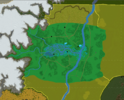 Current Project Map.png1.3 MB · Views: 169
 -
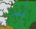 Expanded Project Map.png1.2 MB · Views: 317
 -
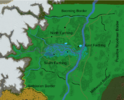 Expanded Project Map Regions.png1.2 MB · Views: 294
 -
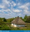 ethnic-medieval-rural-house-green-forest-glade-ethnic-medieval-rural-house-green-forest-glade-...jpg372 KB · Views: 156
 -
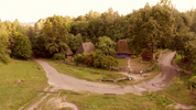 videoblocks-old-small-village-in-a-forest-medieval-countryside-life_hu4lx8dci_thumbnail-1080_01.png4.2 MB · Views: 172
Last edited:
