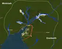
• Welcome to MCME!

    Minecraft Middle Earth is a Minecraft community that recreates the world described by JRR Tolkien and his writings. Everyone can participate in organized events in which we collaborate to create major landmarks, terrain, caves, castles, towns, farms and more.

    To get started, visit The New Player Guide

    Joining the server

    Joining the server can be done straight away, but you will have to pass the New Player Quiz. Use the The New Player Guide to get acquainted with our community.

    IP: build.mcmiddleearth.com

In Progress Lond Daer Terrain

Fireinferno13

One Of Us, One of Us
Commoner
Credits
0
XP
0
Lond Daer Terrain
Current Progress: In Progress

Co-Leaders: Fireinferno13 and Ivanp1l

Project Summary:
The terrain within and surrounding Lond Daer is to be redone. This includes reducing some of the original seaside cliffs, adding logical river sources, redoing worldpainter terrain, and so forth. This project is not a priority per say and should not indicate that Lond Daer will be tackled any time in the near future.

General Lore:
Lond Daer, or "New Haven", was founded by the Numernorians between SA 750 and 800. It was the first permanent settlement of the Numenoreans in Middle Earth. They began heavily harvesting local timber for ship-building, to the point that large regions of the Enedwaith and Minhiraith became deforested. This led to frequent conflicts with the local native populations.

Sauron burnt what remained of the Enedwaith and Minhiraith forests, starving the shipyards of timber, following the war between Elves and Sauron in the Second Age. This partially led to the gradual decline of Lond Daer, and power shifted to the newly settled lands in the south, such as Pelargir, as well as in the north, such as Tharbad. The city was eventually abandoned, though it remained on maps and some ruins were still visible as late as the end of the Third Age.

While Enedwaith (SE) was completely decimated by both deforestation and Sauron's attacks, filling with fenlands in its place, Minhiriath (NW) was apparently still thickly forested in a few locations despite showing signs of over-harvesting and war.

Project Layout:
13653


Project Progress:
  1. Nuke Old LD
  2. Terraforming:
    1. Minhiraith Border (North) & Estuary - Ivan
    2. Lond Daer & Surrounding - Fire
    3. Enedwaith(South) - Fire
      • Boundaries marked by main rivers accordingly
  3. Add Terrain Details:
    1. River Sources
    2. Connecting Road
    3. Vegetation
    4. Minimal Forestation
 

Attachments

  • Screen Shot 2019-06-12 at 3.19.11 PM.png
    Screen Shot 2019-06-12 at 3.19.11 PM.png
    1.1 MB · Views: 439
Last edited:
I have finished the terrain for both the Enedwaith and Lond Daer/Lond Daer surroundings. Moving on to the estuary NE of Lond Daer as well as the region bordering Minhiriath.

Ivan is going to handle river sources in completed areas.

As for vegetation and terrain detailing, I intend to add some smaller bushes and rocks as well as just a few trees here and there. I like this concept art from Tolkien Gateway concerning what Minhiriath should look like. From what I can tell from the lore it seems like the area closest to Lond Daer never quite recovered following deforestation and burning, though dense forests still remained in the outskirts of the region (which this project is not dealing with).

We may also add a fisherman/hunter camp or two, the lore also indicated that the region was very sparsely populated in the third age.

13658
 
I made a list of quotes about Lond Daer.

From those I think the terrain should be not swampy (like around Tharbad) but very low hills only, probably nowhere higher than y = 20 to 30. Lond Daer seems to have been similar size as Pelargir at the end of Second Age with huge shipyards and quais for loading wood onto ships. Tharbad was heavily fortified, not even Sauron was able to endanger it during his war in Eriador.

I think we should change the terrain a much more. The Gwathló is the greates River of Eriador and second only to Anduin the Great in the north west of Middle-earth. It has a much larger bassin area than all streams of southern Gondor. I would make it about 80 blocks wide and much wider (200 - 300) at Lond Daer as the mouth is funnel-shaped and Lond Daer is at the estuary of the mouth.
Would look like this:
13668
 
I made a list of quotes about Lond Daer.

From those I think the terrain should be not swampy (like around Tharbad) but very low hills only, probably nowhere higher than y = 20 to 30. Lond Daer seems to have been similar size as Pelargir at the end of Second Age with huge shipyards and quais for loading wood onto ships. Tharbad was heavily fortified, not even Sauron was able to endanger it during his war in Eriador.

I think we should change the terrain a much more. The Gwathló is the greates River of Eriador and second only to Anduin the Great in the north west of Middle-earth. It has a much larger bassin area than all streams of southern Gondor. I would make it about 80 blocks wide and much wider (200 - 300) at Lond Daer as the mouth is funnel-shaped and Lond Daer is at the estuary of the mouth.
Would look like this:
Firstly, in terms of expanding the estuary, I think that sounds reasonable to me and is easily done.

Secondly, what do you think of the current rolling hills surrounding Lond Daer? I tried to make them somewhat as many descriptions seemed to suggest that all that remained in this region, especially directly surrounding Lond Daer, were grass plains. Also somewhat limited as I don;t want to make the transition from LD terrain to worldpainter terrain too jarring as the scope fo this project is quite small relatively speaking.
 
I think there should be a wide plains area along both banks of the river. The hills still seems way to steep to me. But my main issue are all the depressions. Having paths (valleys) for water to flow down (in streams or underground to the ocean from every single location is my main design criterium for terrain and very important to me.

There don't need to be steams in all valleys, but quite a lot imo. More than currently planned. I think West Anorien is best example I have. Though that is not a plain but hilly terrain close to mountains. The Lond Daer terrain shoud be much more flat. But that's just my two cents :p
 
I placed woolmarkers for valley layouts (small blue dots, hard to see at sandy area, sorry):
13689
This is how I would remove all depressions without drainage. This is my very basic observation from real world terrain, depressions are VERY rare (only in very special geological formations like karst regions or deserts.
I would not put streams in all valleys though but rather dig them with /b e melt and then smooth again.
 
I placed woolmarkers for valley layouts (small blue dots, hard to see at sandy area, sorry):
This is how I would remove all depressions without drainage. This is my very basic observation from real world terrain, depressions are VERY rare (only in very special geological formations like karst regions or deserts.
I would not put streams in all valleys though but rather dig them with /b e melt and then smooth again.
Thats very helpful thank you @Eriol_Eandur , but I am a little confused by how far this project is suppose to extend. I was under the impression from @barteldvn that I was only to work on the region that is currently sandy in your above screenshot?
 
Thats very helpful thank you @Eriol_Eandur , but I am a little confused by how far this project is suppose to extend. I was under the impression from @barteldvn that I was only to work on the region that is currently sandy in your above screenshot?
I'd definitely start with that area. You can do more if it goes well and doesn't take too much time
 
Project Update:
Terrain in sections #1 and #5 have been redone in order to incorporate more realistic drainage/erosion. Currently working on section #2.

@Eriol_Eandur and @barteldvn if you would like to check any of the regions converted to stone, I would consider them mostly done. Though @Ivan1pl is going to work on derp fixing and smoothing in these portions.

We are going to hold off on adding river sources until these regions have been checked off accordingly.

If all goes well, I would like to propose the peninsula bordering the great Sandrast to be considered part of this project :)

13702
 
Looks good, just a few spots with realism issues imo. This screenshot displays two of them:
1. The valley has a completely flat floor but at the bottem of the picture the inclination of the valley foor suddenly increases.
2. At the place maked in yellow the valley has two "exits" one to the right and one to the bottom.
Both features are VERY rare in real world terrain and require special geological formations which don't seem reasonable here. Issue 1. is quite frequent especially at the ocean shore.
13703
 
Looks good, just a few spots with realism issues imo. This screenshot displays two of them:
1. The valley has a completely flat floor but at the bottem of the picture the inclination of the valley foor suddenly increases.
2. At the place maked in yellow the valley has two "exits" one to the right and one to the bottom.
Both features are VERY rare in real world terrain and require special geological formations which don't seem reasonable here. Issue 1. is quite frequent especially at the ocean shore.
View attachment 13703
So picky :p
 
1) QUESTION: Any comments/concerns about the roads connecting Lond Daer to Tharbad (North) and Rohan (East)? I am interested in having these two connecting roads run as jobs and am currently working to ensure the routes are as logical and smooth as possible. If anyone thinks the route should change please post your concerns sooner rather than later. They are both marked in wool respectively if you would like to check them out in game.
13902

2) UPDATE: Making good progress overall on the regions south and east of Lond Daer (green). Will continue to work inwards with the help of Ivan and Bart. River source jobs (blue) are open in grassed regions, respectively. Just let me know if any foreman or artists would like to work on them.
13904
 
Last edited:
I'm not convinced about the roads. First these roads woudn't been used for almost 3000 years.
But my more important issue is that the geography of Eriador isn't well represented at our map (we should rotate Tharbad by 90 degree). Look at this map from the Atlas
13909
The Gwathló is a very large river almost comparable with Anduin the Great and the bridge of Tharbad is very prominent in Tolkiens writings. Another bridge west of Tharbad doesn't make sense in my opinion. Also there was little use for a road between Lond Daer and Tharbad during Second Age. The Numenoreans used the river for all transports and at the beginning of Third Age Lond Daer was abandoned very quickly. The southern road seems also quite useless to me. While Lond Daer existed there was no Isengard, no Rohan and no Gondor. Next numenorean settlements were Dol Amroth and Pelargir which are much better accessible by ship.
So if any road I'd build it along the river to connect with Tharbad, but it would probably be more for quick riders than heavy carts. So very little remains.
 
I'm not convinced about the roads. First these roads woudn't been used for almost 3000 years.
But my more important issue is that the geography of Eriador isn't well represented at our map (we should rotate Tharbad by 90 degree). Look at this map from the Atlas
The Gwathló is a very large river almost comparable with Anduin the Great and the bridge of Tharbad is very prominent in Tolkiens writings. Another bridge west of Tharbad doesn't make sense in my opinion. Also there was little use for a road between Lond Daer and Tharbad during Second Age. The Numenoreans used the river for all transports and at the beginning of Third Age Lond Daer was abandoned very quickly. The southern road seems also quite useless to me. While Lond Daer existed there was no Isengard, no Rohan and no Gondor. Next numenorean settlements were Dol Amroth and Pelargir which are much better accessible by ship.
So if any road I'd build it along the river to connect with Tharbad, but it would probably be more for quick riders than heavy carts. So very little remains.
Just so I am understanding you - you are recommending removing the road east to Rohan (orange) (I agree with your logic) and connecting the road north to Tharbad on the eastern side (green) rather than the western side (yellow)? As a result the crossing will be over a minor stream rather than the Gwathlo.

I also agree with your point about making the road quite scarce, as it likely was rarely used if at all after the fall of Tharbad.
13910
 
Top