North of Mordor:
Dead Marshes, No-man Lands, Dagorlad
Project Leader: Fireinferno13
Project Staff: Tyranystrasz, mattlego
Updated: October 24th
IntroductionDead Marshes, No-man Lands, Dagorlad
Project Leader: Fireinferno13
Project Staff: Tyranystrasz, mattlego
Updated: October 24th
Given my project has bitten off a bit more than it can chew, I wanted to lay out some future projects. I think its important to mark out where everything should be given that I have been tampering with all the layouts. Not saying I am leading them, might be interested, but just wanted to put my two cents together in a legible fashion. While originally our goal with adjusting the Mordor terrain was simply that, I think it is really important that we use this as an opportunity to incorporate the lore of this region without neglecting the space between key locations. Please do not hesitate to add your feedback to the following project post and I will do my best to incorporate suggestions into this post as we go.
Map
Projects:
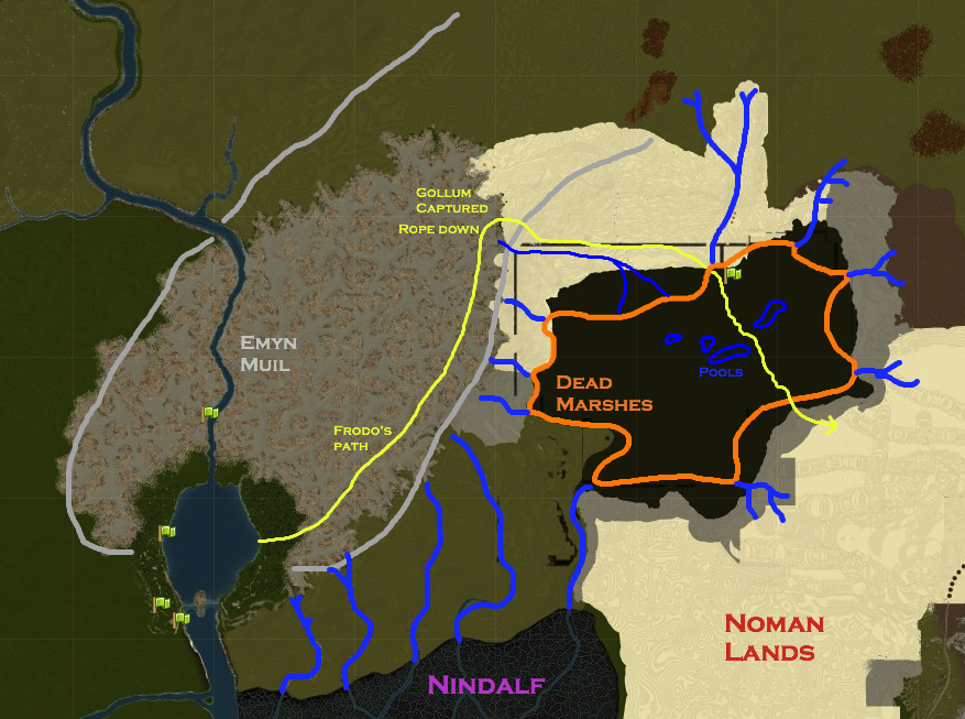
The Dead Marshes Prep (orange)Project Leader: Fireinferno and mattlego
Progress: done!
Description: A reeking wetlands that lay northwest of the Dagorlad and southeast of the Emyn Muil. They may have been an extension of the Nindalf although the two swampy areas are separately named and seem to be disconnected on maps of the region. The marshes were an endless network of pools and soft mires filled with water-courses, and in the dark waters could be seen the dead from battles of long ago. Frodo, Sam and Gollum observe candles and faint lights during the excursion through the dead marshes.
No-man Lands (light red):Progress: done!
Description: A reeking wetlands that lay northwest of the Dagorlad and southeast of the Emyn Muil. They may have been an extension of the Nindalf although the two swampy areas are separately named and seem to be disconnected on maps of the region. The marshes were an endless network of pools and soft mires filled with water-courses, and in the dark waters could be seen the dead from battles of long ago. Frodo, Sam and Gollum observe candles and faint lights during the excursion through the dead marshes.
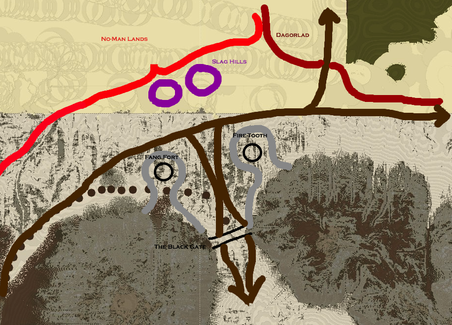
Project Leader: Fireinferno13 and mattlego
Progress: wip
Description: This region is described as long shallow slopes, arid moors, and sedimentary layers of earth and rock. Frodo, Sam, and Gollum had to cross these lands on their trek toward the Black Gate. This should transition smoothly into Dagorlad.
Dagorlad (dark red):Progress: wip
Description: This region is described as long shallow slopes, arid moors, and sedimentary layers of earth and rock. Frodo, Sam, and Gollum had to cross these lands on their trek toward the Black Gate. This should transition smoothly into Dagorlad.
Project Leader: none
Progress: planned
Description: The name in Sindarin means "battle plain." A large treeless and barren wasteland devoid of both life and beauty. There were many battles that occurred here, including that between the last alliance and sauron, leaving behind sumps of poisonous pools and scorched earth. Hence, this terrain should be largely open to reflect the fact that armies chose this spot to wage war.
Notable Paths:Progress: planned
Description: The name in Sindarin means "battle plain." A large treeless and barren wasteland devoid of both life and beauty. There were many battles that occurred here, including that between the last alliance and sauron, leaving behind sumps of poisonous pools and scorched earth. Hence, this terrain should be largely open to reflect the fact that armies chose this spot to wage war.
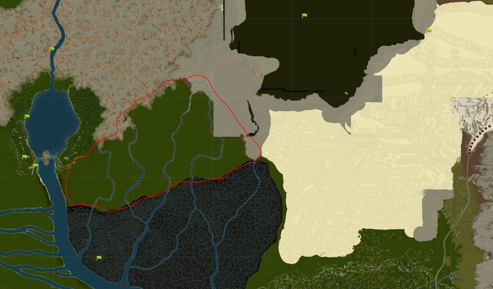
Frodo and Sam's Path (yellow): After the breaking of the fellowship, Frodo and Sam continue east through the Emyn Muil. However, the steep cliffs of the Emyn Muil's southeastern border forced the two north until the slopes softened just enough for them to use their elvish rope. This is where gollum falls in pursuit (marked), and the two hobbits are able to overpower him. The three then continue through the Dead Marshes, up the slopes of the Noman Lands where they hide in a hollow just outside the Black Gates to try and figure out a way in. After that failed plan, they head south through Ithilien where they are captured by Faramir.
The Road to Mordor (brown): As noted by @Eriol_Eandur , there should be three roads that converge at the black gate. One from the east along Ered Lithui (the ash mountains), one from the north (to Dol Goldur), and one from the south through Ithilien.
Last edited:

")